
Biodiversity Assessment Method

What is the Biodiversity Assessment Method and why does it exist?
The purpose of the Biodiversity Assessment Methodology (BAM) is to provide a standardised framework to undertake environmental assessments in accordance with the the Biodiversity Conservation Act 2016 (BC Act).
The Biodiversity Conservation Act 2016 (BC Act) together with the Biodiversity Assessment Methodology (BAM) commenced on the 25th August 2017. The BAM now applies to all of New South Wales. You can access the Biodiversity Conservation Act (2016) by clicking here.
The BAM details how the following reports must be prepared:
Biodiversity Development Assessment Reports (BDAR)
A Biodiversity Development Assessment Report (BDAR) is an environmental report that is submitted as a supporting document in a Development Application (DA) (e.g. dwelling, subdivision, shed, driveway, granny flat) or state significant development (SSD) (e.g. residential village, school, hospital, warehouse, shops, factory) under Part 4 of the Environmental Planning and Assessment Act 1979. The BDAR will assess the environmental impacts of the proposed development on threatened species, populations and ecological communities. The report will also identify how you (as the developer or their delegate) will propose to avoid, minimise and offset impacts from your proposed development.
Biodiversity Certification Assessment Reports (BCAR)
A Biodiversity Certification Assessment Report (BCAR) is similar to a BDAR but is for large-scale, staged development proposals . A BCAR involves an accredited assessor applying the new Biodiversity Assessment Method (BAM) to document the biodiversity values of the land being certified and assessing the impacts of developing that land (including offset credits and other conservation measures).
Biodiversity Stewardship Site Assessment Reports (BSSAR)
A Biodiversity Stewardship Site Assessment Report (BSSAR) is a report that assesses land to be used for conservation. The land may become a stewardship site to be maintained long-term and possibly re-vegetated to preserve the native vegetation on site. This site will have the opportunity to produce stewardship credits that may be purchased to offset impacts assessed under a BDAR, possibly acting as a long-term investment.
In order to undertake the BAM, Accredited Biodiversity Assessors must enter field-collected data into the ‘Biodiversity Assessment Calculator’ and determine the number and class of ‘biodiversity credits’ the proposed development will need to ‘retire’ in order to meet their offset obligation and achieve approval by the regulatory authorities.
The BAM can only be applied by Accredited Assessors under the BC Act. View Narla’s Accredited Assessors below.
How to determine if my development or proposal requires me to engage an Accredited Assessor?
The Biodiversity Assessment Methodology (BAM) provides a clear, mandated framework to be implemented for all NSW projects that trigger one (or more) of three entry thresholds:
1. Biodiversity Values Mapping:
Clearance of native vegetation or prescribed biodiversity impacts within land mapped as ‘Biodiversity Values’ by the Department of Planning, Industry & Environment (DPIE).
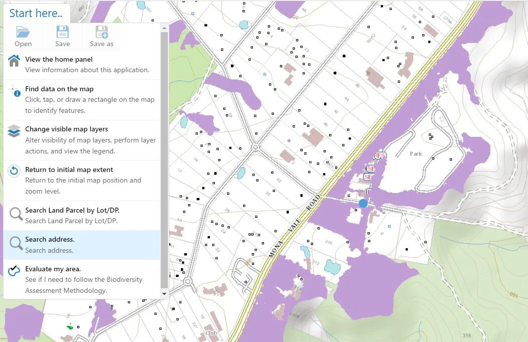
You can access the NSW Biodiversity Values Map by clicking here. Click on ‘Start Here’ and select ‘search address’ from the drop down menu. If you see any land mapped as purple on your selected property, this purple land is protected by the State for its biodiversity values. Clearing any of this purple-mapped land will trigger the BAM.
Department of Planning, Industry and Environment (DPIE) (2020) Biodiversity Values Map and Threshold Tool
2. Exceeding Clearing Thresholds:
The BC Act and its regulations stipulate clearing ‘area threshold’ values that determine whether a development will trigger the BAM. This area is determined by the minimum lot size of the property. You can find your minimum lot size by accessing the NSW ePlanning Spatial Viewer here. Search for your property by address on the left and the minimum lot size will be listed in the table on the right.

Department of Planning, Industry and Environment (DPIE) (2020) ePlanning Spatial Viewer https://www.planningportal.nsw.gov.au/spatialviewer/#/find-a-property/address
Clearing Area Thresholds

If you plan on clearing more than the associated threshold for clearing, you will be required to provide a Biodiversity Development Assessment Report (BDAR) to the approval authority (e.g. your Local Council for local DA, or the NSW Department of Planning for Major Project/SSD) as part of your development application (DA), major project SSD proposal, or tree clearing application. A BDAR will be placed on public exhibition with the relevant application.
3. Significant Impact:
Implementation of a ‘Test of Significance’ (5-part test) will determine whether impacts from development will have a ‘significant impact’ under section 7.3 of the Biodiversity Conservation Act 2016 on biodiversity (in particular, threatened species or threatened vegetation communities). This 5-part test is produced by a qualified Ecologist as part of a Flora and Fauna Assessment Report (FFA) or Biodiversity Development Assessment Report (BDAR). A 5-part test includes the following questions:
In the case of a threatened species, whether the proposed development or activity is likely to have an adverse effect on the life cycle of the species such that a viable local population of the species is likely to be placed at risk of extinction;
In the case of an endangered ecological community or critically endangered ecological community, whether the proposed development or activity:
Is likely to have an adverse effect on the extent of the ecological community such that its local occurrence is likely to be placed at risk of extinction, or
Is likely to substantially and adversely modify the composition of the ecological community such that its local occurrence is likely to be placed at risk of extinction.
In relation to the habitat of a threatened species or ecological community:
The extent to which habitat is likely to be removed or modified as a result of the proposed development or activity, and
Whether an area of habitat is likely to become fragmented or isolated from other areas of habitat as a result of the proposed development or activity, and
The importance of the habitat to be removed, modified, fragmented or isolated to the long-term survival of the species or ecological community in the locality.
Whether the proposed development or activity is likely to have an adverse effect on any declared area of outstanding biodiversity value (either directly or indirectly); and
Whether the proposed development or activity is or is part of a key threatening process or is likely to increase the impact of a key threatening process.
Mapped Important Areas
For species that are highly mobile, determining their presence or absence at a site based on targeted surveys is problematic, which has led to ongoing loss of their core habitat. However, there are a few threatened species that the NSW DPIE have extensive, long-term datasets for that indicate parts of the landscape that are particularly important for their persistence. Mapped important areas identifies land that supports critical life stages (e.g. breeding sites, foraging habitat for migratory species) for these difficult to detect threatened species.
For BDAR’s:
In mapped areas the species is considered present and therefore if your development impacts a mapped important area, no survey is required and the species must be offset accordingly.
For BSA’s:
If your Biodiversity Stewardship Site contains mapped important areas, the species is also assumed present and you are able to generate the corresponding species credits.
Our BAM Accredited Assessors
Please contact one of our Accredited Assessors to find out how we can assist you:

Dr Jack Tatler
General Manager | Senior Ecologist
Accredited Biodiversity Assessor
T: 02 9986 1295 | M: 0417 130 585

Chris Moore
Project Manager | Ecologist
Accredited Biodiversity Assessor
T: 02 9986 1295 | M: 0428 388 491

sarah cardenzana
Project Manager | Ecologist
Accredited Biodiversity Assessor
T: 02 9986 1295 | M: 0437 368 845
Narla Environmental is an industry leader with extensive experience in producing high-quality Biodiversity Development Assessment Reports, Flora and Fauna Assessment Reports and Ecological Constraints Assessments for DA.
We have offices and staff in Sydney, Western Sydney, Newcastle and the South Coast of New South Wales. We service the whole of New South Wales, including Greater Sydney, Western Sydney, Central Coast, Newcastle, Blue Mountains, Hunter Valley, Wollongong and Illawarra, Southern Highlands, Eurobodalla, Shoalhaven, Port Macquarie, North Coast, Central West and the rest of regional New South Wales.

Contact Narla Environmental