Biodiversity Value Map Review
What is a Biodiversity Values (BV) Map?
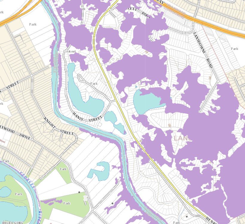
The Biodiversity Values (BV) Map ( ‘the Purple Map‘) is a map managed by the NSW Government that identifies land that it deems to be sensitive to impacts relating to vegetation clearing associated with development, especially developments carried out in accordance with Part 4 of the NSW Environmental Planning & Assessment Act (EP&A Act).
Narla provide assistance interpreting/reviewing the Biodiversity Values (BV) Map (Purple Map) when submitting a Development Application (DA) in Sydney and the rest of NSW.
The map forms part of the Biodiversity Offsets Scheme Threshold which is one of the triggers for determining whether the Biodiversity Offset Scheme (BOS) applies to a clearing or development proposal. The map has been prepared by the Office of Environment and Heritage (OEH) under Part 7 of the Biodiversity Conservation Act 2016 (BC Act).
If you intend on carrying out a development, and are seeking a Development Application (DA) on your land, you must first check that the land is or is not mapped ‘purple‘ on the ‘Biodiversity Values Map’.
What if My Land is Mapped ‘Purple’ on the Biodiversity Values Map?
If all/part of your proposed development site is mapped ‘purple’ and you intend on clearing native vegetation for your development, your development will trigger the Biodiversity Offset Scheme (BOS) and you will be required to submit with your DA a Biodiversity Development Assessment Report (BDAR).
A BDAR will result in you either having to offset the impacts of your development by purchasing/generating and retiring of ‘biodiversity offset credits’ or allocating a fee into the NSW Biodiversity Conservation Trust fund. The costs of this can be substantial and have significant financial implications on developments.
If you intend to develop on land that is added to the BV Map, your development does not trigger the Biodiversity Offset Scheme if:
The land is the subject of a planning approval made up to 90 days after the land is added to the BV Map;
The land was already the subject of a planning approval when the land was added to the BV Map;
You are not clearing any native vegetation (i.e. not removing ANY native trees, shrubs or ground cover including grasses and herbs) AND you have sufficient evidence to confirm this AND you can confirm there will be no ‘indirect’ or ‘prescribed’ impacts from your development in this area; or
The development or activity is considered not likely to significantly affect threatened species, or ecological communities or their habitats based on the test of significance in section 7.3 of the BC Act.
Call: 02 9986 1295
Email: reception@narla.com.au
Contact Narla to Find Out if Your Property is on the BV Map:
Do you believe the Biodiversity Value Map over your property is incorrect? How to Request to Update /Change The Mapping
It is possible that the Biodiversity Value Mapping over your property has incorrectly identified areas of biodiversity sensitive land. This is because of the way the mapping is developed, sometimes the data that informs the development of the mapping has been produced to a low level of granularity/accuracy that it encompasses areas that really should not be classified as Biodiversity Sensitive, and therefore should not really be coloured purple on the BV Map. This is a common phenomenon when developing new data sets from one or more existing data sets using ‘geographical information systems’ (GIS).
Narla Environmental can help you request a review of the Biodiversity Value Map for your property if you feel a value has been incorrectly mapped. A review may result in an update/change to the Biodiversity Value Mapping. To achieve this you will need to provide sufficient evidence to prove that your site is not biodiversity sensitive. This evidence is best provided in the form of a factual, map-based report developed by an experienced and qualified Ecologist such as Narla Environmental Pty Ltd.
Once the intended changes are accepted, the online Biodiversity Value ‘purple map’ will remain unchanged for at least 90 days. Only after the 90 days, and after the mapping has changed, will you be able to submit your DA without a BDAR. Areas added to the BV Map in the last 90 days are shown in dark purple to distinguish them from areas that have been on the map longer than 90 days which are shown in light purple.
Contact Narla to help you obtain/provide the evidence needed to review the Biodiversity Value Map over your property.
Determine if you need to submit a Biodiversity Development Assessment Report (BDAR) with your Development Application
The Biodiversity Conservation Regulation 2017 sets out threshold levels for when the Biodiversity Offsets Scheme (BOS) will be triggered, and the need for a Biodiversity Development Assessment Report (BDAR) will arise for your development. Determining the threshold has two main elements:
Whether the amount of native vegetation being cleared exceeds a threshold area set out below; or
Whether the impacts occur on an area mapped on the Biodiversity Values map published by the Minister for the Environment.
Contact Narla Environmental to find out if your property is included on the Biodiversity Value Map
If native vegetation clearing and/or other impacts exceed the threshold, the Biodiversity Offset Scheme (BOS) applies to the proposed development and the proponent will be required to prepare a Biodiversity Development Assessment Report (BDAR).
The Biodiversity Development Assessment Report (BDAR) is an official document that identifies how you (as the developer or their delegate) will propose to avoid and minimise impacts from your proposed development upon native vegetation or biodiversity listed under the New South Wales Biodiversity Conservation Act 2016 and the Biodiversity Regulation 2017.
A BDAR will result in you either having to offset the impacts of your development through purchasing/generating and retiring ‘biodiversity offset credits’ or allocating a fee into the NSW Biodiversity Conservation Trust fund. The costs of this can be substantial and have significant financial implications on developments. You should discuss the implications with your financial advisor and an Ecologist, such as Narla Environmental Pty Ltd.
As the proponent, you must provide the BDAR to the approval authority (e.g. your Local Council for local DA, or the NSW Department of Planning for Major Project/SSD) as part of your development application (DA), major project SSD proposal, or tree clearing application. A BDAR will be placed on public exhibition with the relevant application.
The outcomes of the assessment will be included in the BDAR and must be provided to the consent authority. The BDAR will provide consent authorities with consistent and scientifically robust information about non-clearing impacts. The consent authority must consider the information in the BDAR when deciding whether to approve the development proposal and any appropriate conditions to mitigate the identified impacts.
Applying the Biodiversity Assessment Method (BAM)
The Biodiversity Assessment Method (BAM) is the assessment manual that outlines how an accredited person assesses impacts on biodiversity at development sites when preparing a BDAR.
In order to undertake the BAM, accredited assessors (typically Ecological Consultants) must enter field-collected data and determine the number and class of ‘biodiversity credits’ the proposed development will generate. The BAM tool will also assist in the preparation of standardised reports for consent authorities to consider.
An accredited assessor must apply the BAM. The assessor documents the results of the biodiversity assessment in a BDAR.
The consent authority then assesses the application against the requirements of the legislation that the application is being assessed under. The consent authority will determine whether to approve or refuse the application, including by considering the impacts on biodiversity (if any) as outlined in the BDAR.
For the impacts on biodiversity, the consent authority will assess the BDAR against the legal and technical requirements of the Biodiversity Conservation Act 2016, Biodiversity Conservation Regulation 2017 and the BAM.
In order to find out if you need to apply the BAM and develop a Biodiversity Development Assessment Report (BDAR) for your project, get in contact with the planning department of your local council, or call Narla Environmental now on 02 9986 1295.
Councils often request a BDAR when the subject property is located within the ‘Terrestrial Biodiversity’ (or similarly named) mapping layer that forms part a council’s ‘Local Environmental Plan’ (LEP).
Contact Narla Environmental to receive a free, industry-competitive quote suited to your project!
CALL US TODAY - 02 9986 1295
EMAIL OUR OFFICE: RECEPTION@NARLA.COM.AU
We want to help with your project approval process!
If council requires you to submit a Biodiversity Development Assessment Reports (BDAR), it is best that you are well prepared before you prepare the final design of your proposed development. Without doing ‘your homework’ you might be inadvertently designing a construction that will impact on every environmental constraint on your property.
The best way to do this is to undertake an Ecological Constraints Assessment that details all of the ecological or other environmental constraints that may arise during the DA. The sooner you know of these issues, the better prepared you, your Architect or Town Planner will be when submitting the DA.
Not quite at DA stage but interested to know more about your the feasibility of your property for a DA?
If you are contemplating purchasing a property or submitting a DA for property subdivision, dwelling alterations, demolition, construction, we recommend you commission an Ecological Constraints Assessment Report.
A good Ecological Constraints Assessment Report will:
Be low cost to implement;
Save you extensive amounts of time and money down the track;
Help you, your architect, or your planner design a development footprint that gives you your best chance of DA approval;
Inform you if there are additional specialist reports you may need for DA; and
Allow you to most appropriately and efficiently design your development to best avoid difficult environmental constraints in the DA stage, rather than risking possible Council knock-back after DA submission.
Narla Environmental’s Ecological Constraints Reports address all of the relevant environmental constraints you may encounter during the DA stage. They include maps that show the most constrained parts of the property through to the least constrained, along with detailed information on what the constraints entail and how they may be avoided, mitigated or offset in order to facilitate development.
Implementing an Ecological Constraints Report will maximise your development potential while maintaining a strong chance of obtaining DA approval.
Disclaimer: Some of the information presented on this page has been copied directly from the State of New South Wales and Office of Environment and Heritage [2017]. Narla accepts no responsibility for decisions made using information pasted on this website. For more detailed and up to date information visit NSW Office of Environment and Heritage online: http://www.environment.nsw.gov.au
Bushfire Assessments
Cultural Heritage Assessments
Bushland Management Plans
Biodiversity Offsets Reports
BDAR Waiver
Arborist Reports
NARLA ENVIRONMENTAL CAN ALSO HELP YOU OBTAIN THE FOLLOWING REPORTS FOR DEVELOPMENT APPLICATIONS (DA) AND STATE SIGNIFICANT DEVELOPMENTS (SSD):
Narla Environmental is an industry leader with extensive experienced in producing high-quality Biodiversity Development Assessment Reports, Flora and Fauna Assessment Reports and Ecological Constrains Assessments for DA.
We have offices and staff in Sydney, Western Sydney, Newcastle and the South Coast of New South Wales. We service the whole of New South Wales, including Greater Sydney, Western Sydney, Central Coast, Newcastle, Blue Mountains, Hunter Valley, Wollongong and Illawarra, Southern Highlands, Eurobodalla, Shoalhaven, Port Macquarie, North Coast, Central West and the rest of regional New South Wales.
